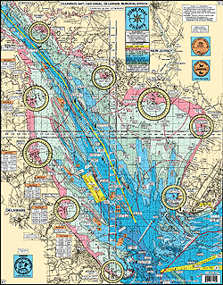
#1 Delaware Bay to the C&D Canal to the Delaware Memorial Bridge
Entire Delaware Bay with an enlargement of the" RIPS"
Great for Kayaking!
New Jersey Side: Cohannesey River, Fortesque, Maurice River, Bidwell Creek, Cape May Canal entrances to the Bay.
Delaware Side: Port Mahon, Bowers Beach, Misspillion, and Roosevelt Inlets
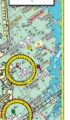
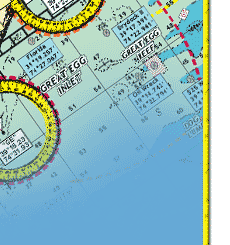
LOCAL KNOWLEDGE FISHING GROUNDS AND HOT SPOTS NOT FOUND ON OTHER CHARTS: Tussey's Slough, Joe's Tip, Top of the Hill, The Valley, Errickson's Steaks, Punk Grounds, Horseshoe, Pin Top, 60' Slough, Tussey's South Tip, 20' Slough, Little Egypt,PLUS Fishing Creek Shoal, Round Shoal, Overfalls Shoal, Prissy Wicks, The Valley, McCries Shoal, Crow Shoal, Hawk's Nest Shoal, Crossover Grounds, The Anchorage, Old Bare Shoal, Broadkill Slough, Joe Flogger Shoal, The Lower Middle, Blake Channel, Cedarbush Hole, C&B, Peanut, New Jersey Delaware State Line
Shows ALL DELAWARE REEF SITES !
* AWESOME BOTTOM STRUCTURE showing holes, shoals, lumps, and bumps
*color coded depth and contour curve lines
*laminated-waterproof
*5 mile radius lines from each inlet
*LAT/LON coordinates for entrance buoys/markers at every inlet
*enlarged LAT/LON numbers for easy positioning
*Enlargement of the northern Delaware Bay to the C&D Canal to the Delaware Memorial
Bridge
*Distances listed from the C&D Canal to: Philadelphia, Delaware Memorial Bridge, Cape May Canal, Delaware Bay Entrance, Roosevelt Inlet, DE to Atlantic City, NJ
JOINS CHARTS: #2 Inshore Beach Haven to Cape May NJ to Bethany Beach DE
#28 Delaware River from Trenton, NJ to the Delaware Memorial Bridge
#44 ICW Hereford Inlet to Cape May Harbor Enlargement
|