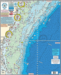
#3 GPS ALL Canyons Chart
Montauk Point, NY to Oregon Inlet, NC
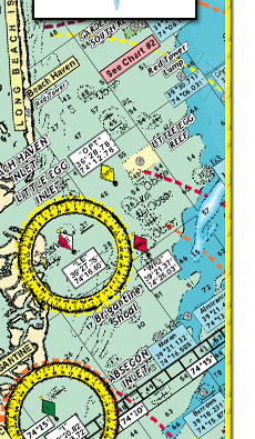
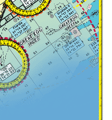
Shows: Montauk Point, Shinnecock, Fire Island, Sandy Hook, Shark River Inlet, Manasquan Inlet, Barnegat Inlet, Absecon Inlet, Cape May Inlet, Ocean City, MD Inlet, Wachaprague, Rudee Inlet, to Oregon Inlet
CANYONS: Chicken Canyon, Hudson Canyon, Toms, Mey, Hendrickson, Lindenkohl, Carterett, Berkeley, Spencer, Wilmington, Baltimore, North Vries, South Vries, North Heyes, South Heyes, Poorman's, South Poorman's Washington, and the Norfolk Canyon
Fishing Grounds: Mud Hole, Monster Ledge, Mako Hotel, The Point, No Name Shoal, 42 Fathom Basin, The Tongue, The Flats, Babylon Valley, Emery Canyon, Uchupl Canyon, West Twin Dipper Canyon, Letters South, Letters North,1000 Fathom Tip, Jones Valley, Hudson Seamount, Mey Canyon, Hendrickson Canyon, The Funnel, Doc Strobel, Toilet Seat, Alligator Bight, North Vries and South Vries Canyons, Triple 0, 461, 471 Hump, Rock Pile, Lobster Pots,Tarheel Mountain, Northeast Grounds, and more.
* Laminated - Waterproof
* Color coded depth and contour curve lines
* LAT/LON coordinated for every inlet
* 84+ Wrecks and Reefs with GPS coordinates
* Depths in Fathoms
Joins Charts #6 Mudhole Chart - Sandy Hook south to Ocean City NJ
#7 Manasquan to Townsends Inlet out 20 miles
#10 Tuna Chart Bottom Structure Chart from Barnegat south
to Ocean City MD
#12 GPS Canyons Chart Hudson to the South Poormans
#15 Tuna Chart Loan & GPS Cape May, NJ to Ocean City MD, to Chincoteague, VA to Rudee Inlet
#34 Shrewsbury-Navesink- Metedeconk- Shark-Manasquan
Rivers
#42 Raritan Bay and Ocean out 20 miles from Jones Inlet, NY
to Manasquan Inlet, NJ |