#34 Shrewsbury-Navesink-Metedeconk-Shark-Manasquan Rivers
Enlarged Rivers
ALL GPS Great for Kayakers!
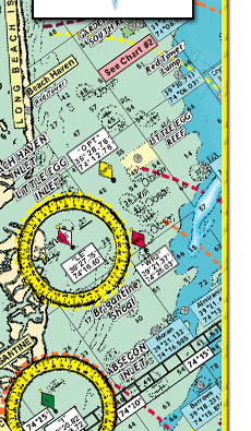
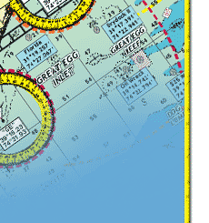
Shows: Sandy Hook Bay, Sandy Hook Channel, Navesink River, Shrewsbury River, to Little Silver Creek, Town Neck Creek, Parkers Creek, Horseneck Point, and Oceanport Creek, out to Troutsmans Creek, enlargement of Shark River Inlet to Shark River through Belmar, to New Bedford and Manasquan Inlet (enlarged) to Pt. Pleasant to Brielle, to the Pt. Pleasant Canal and the Metedeconk River from Mantoloking to Bricktown, to Metedeconk
*Holes and humps shown
*Markers and buoys highlighted
*Boat Ramps shown
*Clearly marked anchorages shown
*Laminated-waterproof
*Color coded depth and contour curve lines
*Artificial Reefs show: Sandy Hook Reef-Sea Girt Reef-Mantoloking Reef
Joins Charts #6 Mud Hole Chart Sandy Hook to Ocean City NJ
#7 Manasquan to Graet Inlet out 20 miles
#16 Inshore Shark River-Manasquan-Barnegat Inlets
#22 ICW Manasquan Inlet to Barnegat Bay to Manahawkin Bay
#42 Raritan Bay & Ocean from Jones Inlet NY to Manasquan
Inlet NJ out 20 miles
|