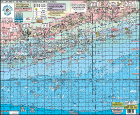
#43 LOWER KEYS
BIG PINE, CUDJOE, SUMMERLAND KEY, KEY WEST, MARQUESAS, to REBECCA SHOAL
LOCAL KNOWLEDGE 'HOT SPOTS' AND FISHING GROUNDS
Awesome Bottom Structure
All GPS
94 + Wrecks and Reefs
Color coded depth and contour curves
Enlarged LAT/LON numbers
Laminated
Fishing grounds: Woods Wall, Ups and Downs, Key West Hump, West Crack, Middle Crack, East Crack, 900' Hole, Start of the Bar, End of the Bar
Wrecks: F.T. Berry, Vandenberg, Wilkes Barre, USS Kendrick, USS Saufley, Lola, LSMR, Joe's Tug, Aquanaut, Airplane, USS Curb, Adolphus Busch, Papa Joe, Barley Wreck and more.
Shoals Shown: American, Pelican, Big Pine, Cosgrove, Half Moon, Issac, Rebecca
Eastern and Western Dry Rocks
Joins Chart
#38 Upper and Middle Keys
|