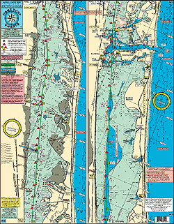
Huchinson Island, Jensen Beach, Stuart, Port Salerno, Hobe Sound, Jupiter Island, to Peck's Lake
LOCAL KNOWLEDGE AND 'HOT SPOT' FISHING GROUNDS
Shows enlarged Ft Pierce Inlet and St Lucie Inlet, Jensen Causeway, Stuart Causeway, North Bridge, South Bridge
Laminated
Color Coded
Red and green daymarkers and lighted daymarkers shown
Statute Miles throughtout
Public boat ramps and Marinas
Bridges with their vertical clearance
Public Parks
Ambush Zones with fish species shown
Great for Kayaking!
Dredge Holes, ambush zones and local Fishing grounds: Erwin Cove, Hells Pocket, Bradley's reef, Fish Haven Cove, Snapper Cut, Thumb Cove, Turing Basin, Faber's Cove, Old Herman's Bay, Catfish Bay, Horseshoe Bar, Hoggs Cove, Boyscout Island, Bird Island, Marcia's Flat, Sailfish Point Flats, Hole in the Wall, Snapper Island, Hell's Gate, and many, more.
Joins Charts:
#51 St Lucie River with the Winding North Fork
#46 ICW Peck's Lake to Lake Worth Lagoon and Loxahatchee River
#36 Inshore Sebastian Inlet to Jupiter Inlet
#48 Northern Swordfish
|