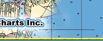
#48 NORTHERN SWORDFISH, DEEP DROP, TUNA CHART
Ft Pierce Inlet to St Lucie Inlet to Jupiter Inlet to Palm Beach Inlet to Boynton Inet to Boca Raton Inlet to Hillsboro Inlet
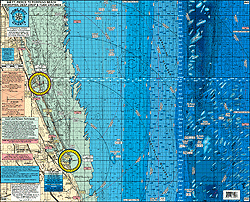
LOCAL KNOWLEDGE 'HOT SPOTS' AND FISHING GROUNDS
Highlighted 76* 45 line in red to show central swordfish grounds
Highlighted TUNA and DEEP DROP SPOTS shown
Awesome Bottom Structure out 50 miles
Highlighted 45 line
All depths in feet
Swordfish regulations
Dolphin and wahoo regulations
Radius lines from each inlet
Color coded depth and contour curve lines
Enlarged LAT/LON numbers for low light night fishing
Laminated
Fishing Grounds with their LAT/LON coordinates for: Ft Pierce Canyon, St Lucie Humps, Catch All Slough, North Hump, South Hump, West Hump, Joe's Deep Hump, Bob's AM Hot Zone, 2002 Hump, Jupiter Hump, Tje Fingers, Beerman, Palm Beach Canyon, 45 Square, V Spot, Willie's Lump Lumps, Delay Triangle, Gary's Spot, Boca Canyon, Hillsboro Canyon, Pompano Canyon
Joins Charts
#35 Swordfish Chart from Hillsboro Inlet south to Key Largo
#37 Inshore from St Lucie Inlet to Hillsboro Inlet
#36 Inshore from Sebastian Inlet south to Jupiter Inlet
#40 Upper Bahamas
|